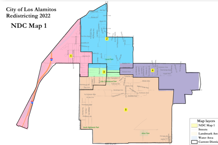
With a new districting plan required to be approved by April 17, the Los Alamitos City Council held a special meeting to stage its second public hearing in which they learned the so-termed “Apartment Row” neighborhood had become overpopulated and has to be split.
Justin Levitt, Vice President of National Demographic Corporation, the city’s consultants, explained in simplified terms what the 2020 decennial census shows about how the city’s makeup has changed.
At an earlier public hearing, Levitt said that while the city redistricted before the 2020 election, not all incumbents were up for election during that cycle; he understood that they were producing new maps even before all of the city’s districts have been used in any election.
Even this year, only voters in Districts 4 and 5 will have a chance to vote, so Council member Mark Chirco urged Levitt to ensure that new districts should allow as many residents as possible who did not get to vote in 2020 (because the incumbents in their districts were not on the ballot) to vote in 2022.
Nevertheless, Levitt gave the panel a glimpse of three proposed maps that have been posted on the city’s website illustrating the newly drawn districts as he explained the criteria within the Fair Maps Act to which the consulting firm must adhere.
Levitt said these criteria are rank ordered and include the following:
• Continuity. Each district geographically must touch each other, and must include major stretches of roads, meaning no small points of connections or corners. Residents must be able to walk or drive along streets without being only partially in a district. “Easily identifiable boundaries are a bit tricky in Los Alamitos,” he said.
• Undivided neighborhoods. Unless otherwise impossible, obvious neighborhoods and communities of interest, including areas that share commonalities or bonds, must be kept together for fair and equitable representation.
• Easy identifiable boundaries. Levitt said boundaries that divide the city’s voting districts must be easily identifiable, including roads, manmade features, jurisdictional subdivisions, etc.
• Compactness. Voting districts should be made as compact as the data will allow but not ignore any group to favor another.
Levitt told the Council that the census shows that District 3, which includes Apartment Row, is clearly overpopulated, perhaps as much as 16 percent, and its voters has to be split in a new districting map.
He presented three maps, each of which has split the voters in Apartment Row in various ways.
Levitt had in an earlier public hearing earlier where he encouraged citizens themselves to suggest the best way to split Apartment Row, saying mapping tools were available on the city’s website.
One resident, Shane Smith, did in fact submit his own map that was submitted to the Council. Smith said one of the tools available on the website required a $4k subscription so he used the less powerful publicly available tools.
He suggested he wanted to create districts that would allow “people that don’t have all the money” to be represented in an appropriate way as those in the monied “islands” within the city. He admitted, however, that Levitt’s maps had more access to data but he wanted to make a point.
“His [Levitt’s] data was better than mine,” said Smith.
“We’re all pretty much in the same district anyway,” said Smith, adding that the city is so small he can walk to three districts within minutes.
Levitt also identified pockets in the city with strong Latino and Asian populations, saying that the final districts will include approximately 2,560 residents each, equally splitting the 11,793 population into five relatively equal voting districts.
Levitt took questions from each of the council members and urged public feedback as the Council will have to choose a final map after the final public hearing, expected this week.
He said the state has set a deadline for April 17 for final approval. He said district’s expecting strong growth were purposely underpopulated by 1.5 percent but the districts, as presented, are all within the 10 percent deviation allowed by government criteria.
“You’re going to have to live with these districts for the next ten years,” said Levitt, urging the council and the public to provide relevant feedback before they are finalized.
In other action, the Council:
• Appointed Mayor Shelley Hasselbrink and Council member Mark Chirco to the newly formed Los Alamitos Community Foundation.
• Appointed Council member Ron Bates as the voting delegate and Mayor Pro-tem Tanya Doby as the alternate for the upcoming Southern California Association of Governments (SCAG) convention.
• Heard a presentation from the Cypress College Americana Awards and formally honored this year’s honoree, former Mayor Troy Edgar.


