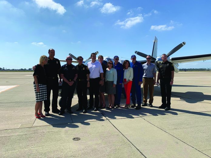
Since it was launched in late September, a new Orange County Fire Authority pilot-project featuring a smart sensor airplane able to use smart sensors and other technologies to fight wildfires has been getting quite a workout.
State and local first responders gathered Sept. 23 at Joint Forces Training Base, where the aircraft associated with the pilot program will be based, to announce the project.
Shelley Hasselbrink, a Los Alamitos city council member who also serves as Vice Chair on the Orange County Fire Authority Board of Directors, said “we are lucky to have the program based here.”
Fire Integrated Real-Time Intelligence System (FIRIS) combines a dedicated fixed-wing aircraft operated by Courtney Aviation equipped with sensors capable of providing enhanced intelligence, surveillance and reconnaissance (ISR), a super computer-based fire prediction system and Intterra’s situational awareness software into one platform to support commanders and decision makers, according to Intterra’s website.
According to the California Department of Forestry and Fire Prevention, there have been over 4,000 fires in California in 2019 so far, even though wildfire season is just beginning. “The State of California must shift strategies to address the constant crisis of wildfires. This is no longer a seasonal threat,” according to Assemblywoman Cottie Petrie-Norris.
Officials say the 150-day pilot program is being funded by a $4.5 million appropriation secured by Petrie-Norris during the most recent session.
Col. Nick Ducich, installation commander of the Joint Forces Training Base, confirmed that the aircraft is being based there for the pilot project, but said there have been so many wildfires in the past three weeks that the planes have not been back to base very often.
Also, he said, he is working through issues with authorities to clear the way for a permanent base at JFTB should the program continue beyond the pilot stage.
Intterra’s interactive platform that distributes critical data and WIFIRE modeling to decision-makers and field personnel. The real-time perimeter fire mapping provides frequent updates on the size, scope, and impact of developing wildfires.
According to the company, FIRIS is intended to significantly first responders, and regional and state emergency operation centers during the first hours of a wildfire, and through extended attack. The UCSD WIFIRE wildfire spread modeling also projects where and how large the fire will before over a 6-hour time period.
Aside from knowing the location of a wildfire, it is imperative for decision-makers to know the direction of the fire in order to save lives and protect homes.
The pilot program is being made available in San Diego, Orange, Los Angeles, Riverside and Ventura Counties, according to the announcement.
Since being launched nearly two months ago, the new Fire Integrated Real-Time Intelligence System (FIRIS) pilot program aircraft has flown more than a dozen missions and provided enhanced situational awareness to numerous fire agencies, according to OCFA.
The FIRIS program is fast becoming one of the first air resources requested by Southern California fire agencies when a wildfire breaks out. The ability of the fixed-wing aircraft, equipped with cameras and infrared and radar sensors that can see through smoke, to provide real-time fire perimeter mapping and live high definition video has made a positive difference for incident commanders and decision-makers located in local Command Centers. Data sent from the twin-engine fixed-wing aircraft has also supported the UC San Diego WIFIRE Laboratory that uses its supercomputer to provide a fire spread progression model to be shared with the incident and command center staff.
“The ability to place resources exactly where they need to be to successfully battle a wildfire can mean the difference between lives and property saved or lost. Technology is becoming increasingly important as we work to suppress wildfires quickly. We’re hopeful this pilot program may someday become a routine asset statewide.” says Orange County Fire Authority Fire Chief Brian Fennessy.
In addition to the high-tech tools being used by the FIRIS pilot program aircraft, Orange County Fire Authority has been supporting its neighbors in Los Angeles with boots on the ground. Currently, four OCFA strike teams are assisting with the Getty Fire.
More than 80 firefighters assigned to ten Type 3 brush rigs, and ten Type 1 fire engines are helping to contain the blaze. In addition, the Southern California Edison (SCE) funded night-time hover-filling helitanker and reconnaissance helicopter are also providing support to the Getty Fire. Two of strike teams had previously been assigned to the Tick Fire with the additional two responding upon immediate request of Los Angeles Fire Department.
“Nothing will replace the need for firefighters on the ground battling out of control wildfires. And I appreciate what our men and women do every day,” said Orange County Fire Authority Fire Chief Brian Fennessy. “I am also thankful that through collaboration, the FIRIS technology is helping to make a difference in decision-making which ultimately leads to suppressing wildfires more quickly.”

